Article by Graham Winter and David Millett, National Assembly for Wales Research Service
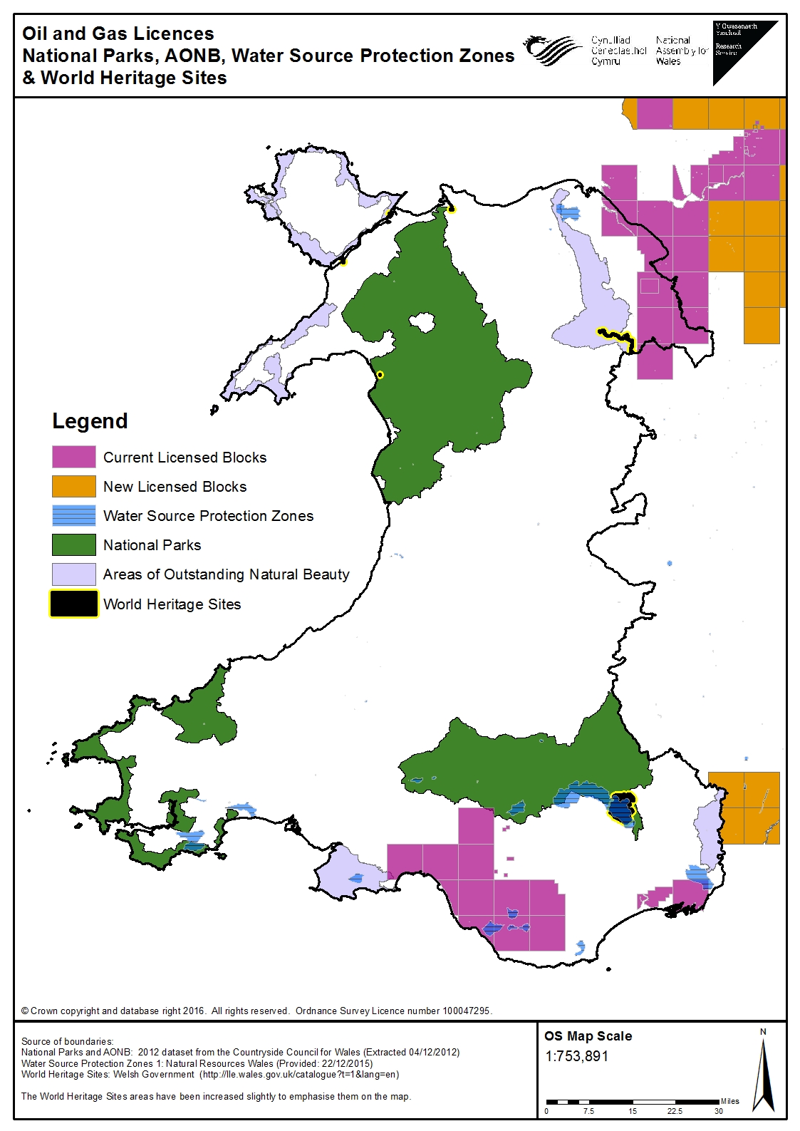
The map shows the ‘licensed block’ areas in Wales where the Department for Energy & Climate Change has issued licences for onshore oil and gas exploration and extraction (known as Petroleum Exploration and Development Licences). These licences were issued as a result of the 13th landward round, or earlier rounds.  The outcome of the 14th landward licensing round was announced by the newly formed Oil & Gas Authority in December 2015. This doesn’t include any new areas in Wales: the UK Government has agreed not to issue any further licences here because it is intended that responsibility for licensing will be transferred to the Welsh Ministers. However some of the new licence blocks in England are close to the Wye Valley AONB and directly adjoin the Welsh border. The map also shows certain “protected areas” that are defined in the Infrastructure Act 2015 and the associated secondary legislation that was approved in the UK Parliament on 16 December 2015. These are National Parks, Areas of Outstanding Natural Beauty, World Heritage Sites and Water Source Protection Zones. The 2015 Act states that the Secretary of State may not issue a hydraulic fracturing (fracking) consent in one of these protected areas. Such a consent is an additional requirement before fracking can take place. Other types of permission and consent are also required – see our earlier blog article. A controversial aspect of the secondary legislation approved in December 2015 is that it would still be possible to drill under one of these protected areas, starting from outside that area, as long as the drilling is at a depth of more than 1,200 metres. Water Source Protection Zones are defined in the legislation as areas of land that groundwater can reach within a 50-day travel time from an abstraction point, where that groundwater is used for domestic purposes or for food production. Natural Resources Wales has provided the boundaries for these zones in Wales. The map shows that the existing licence blocks in most parts do not overlap with these “protected areas”. However there are some Water Source Protection Zones within parts of some of the licenced blocks in south Wales. One licensed block also overlaps slightly with the Brecon Beacons National Park and another with the Gower AONB. In north Wales there are licensed blocks adjacent to the Clwydian Range and Dee Valley AONB and the Pontcysyllte Aqueduct and Canal World Heritage Site.


